1/2


Seaside Buoy
Ocean Temp Tides
1K+下载次数
6MB大小
3.0.0(01-11-2023)最新版本
详情评价版本信息
1/2
Seaside Buoy: Ocean Temp Tides介绍
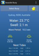
非常适合冲浪,潜水,帆船,游泳或决定是否是去海滩的好时机。检查下一个高潮/低潮的时间。使用主屏幕小部件来监视水。
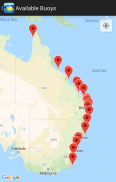
来自世界各地的海洋浮标的实时科学读数。数据由NOAA的国家数据浮标中心和其他公共科学组织提供。大多数浮标报告水温和膨胀高度,但有些浮标比其他浮标更多。自动选择最近的浮标,从地图中选择一个浮标,或从列表中选择。建立一个收藏夹列表,以便快速访问关键浮标。打开设备的位置功能后,计算并显示轴承和浮标的距离。这个应用程序轻巧,易于使用,几乎不需要使用任何数据。
目前,浮标包括在以下位置:
美国,包括阿拉斯加和夏威夷
美属维尔京群岛
波多黎各
加勒比
墨西哥湾
英国
爱尔兰
瑞典
芬兰
爱沙尼亚
拉脱维亚
德国
法国
丹麦
西班牙
亚速尔群岛
葡萄牙
意大利
希腊
火鸡
印度
台湾
迪拜,阿拉伯联合酋长国
澳大利亚
智利
Seaside Buoy: Ocean Temp Tides - 版本3.0.0
(01-11-2023)新特性Widget updates. Fix upgrade bug. Update to API 33.
Seaside Buoy: Ocean Temp Tides - APK信息
APK版本: 3.0.0程序包: com.encdata.OceanTemperature名称: Seaside Buoy: Ocean Temp Tides大小: 6 MB下载次数: 11版本: 3.0.0发布日期: 2024-06-05 01:44:12最小屏幕: SMALL支持的CPU:
程序包ID: com.encdata.OceanTemperatureSHA1签名: DB:16:F1:E0:96:F3:B4:2E:55:B8:37:C4:58:68:38:C9:C4:7D:9F:B1开发商 (CN): Lance Dyer组织 (O): 本地 (L): 国家/地区 (C): 州/市 (ST): 程序包ID: com.encdata.OceanTemperatureSHA1签名: DB:16:F1:E0:96:F3:B4:2E:55:B8:37:C4:58:68:38:C9:C4:7D:9F:B1开发商 (CN): Lance Dyer组织 (O): 本地 (L): 国家/地区 (C): 州/市 (ST):
Seaside Buoy: Ocean Temp Tides的最新版本
3.0.0
1/11/202311 下载次数6 MB 大小
其他版本
2.9.0
12/5/202311 下载次数6 MB 大小
2.8.4
23/3/202311 下载次数7 MB 大小
2.8.1
7/9/202211 下载次数7.5 MB 大小


同类应用


English


